


Footing Moult 2

yannick-p
Gebruiker

Lengte
9,8 km

Max. hoogte
72 m

Positief hoogteverschil
114 m
Km-Effort
11,3 km

Min. hoogte
10 m

Negatief hoogteverschil
113 m
Boucle
Ja
Datum van aanmaak :
2019-02-09 22:28:36.04
Laatste wijziging :
2019-02-09 22:35:08.281
40m
Moeilijkheid : Medium

Gratisgps-wandelapplicatie
 SityTrail
IGN / Geografische instituten
SityTrail Plus
De wereld gaat voor u open
Over ons
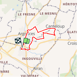
Tocht Lopen van 9,8 km beschikbaar op Normandië, Calvados, Moult-Chicheboville. Deze tocht wordt voorgesteld door yannick-p.
Plaatsbepaling
Land:
France
Regio :
Normandië
Departement/Provincie :
Calvados
Gemeente :
Moult-Chicheboville
Locatie:
Moult
Vertrek:(Dec)
Vertrek:(UTM)
706592 ; 5444262 (30U) N.
Opmerkingen