


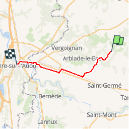
2 - Lelin Lapujolle - 2 rue Pierre Mendés France Aire sur l'Adour

norihtom
Gebruiker

Lengte
13,8 km

Max. hoogte
155 m

Positief hoogteverschil
73 m
Km-Effort
15 km

Min. hoogte
78 m

Negatief hoogteverschil
133 m
Boucle
Neen
Datum van aanmaak :
2019-02-12 13:02:28.557
Laatste wijziging :
2019-02-12 14:22:45.688
3h18
Moeilijkheid : Medium

Gratisgps-wandelapplicatie
 SityTrail
IGN / Geografische instituten
SityTrail Plus
De wereld gaat voor u open
Over ons
Tocht Stappen van 13,8 km beschikbaar op Occitanië, Gers, Lelin-Lapujolle. Deze tocht wordt voorgesteld door norihtom.
Plaatsbepaling
Land:
France
Regio :
Occitanië
Departement/Provincie :
Gers
Gemeente :
Lelin-Lapujolle
Locatie:
Unknown
Vertrek:(Dec)
Vertrek:(UTM)
730741 ; 4844167 (30T) N.
Opmerkingen