


Les Echelles Rochehaut

ramagufa
Gebruiker
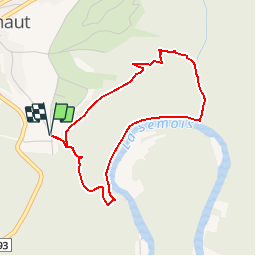

Lengte
3,5 km

Max. hoogte
376 m

Positief hoogteverschil
169 m
Km-Effort
5,8 km

Min. hoogte
207 m

Negatief hoogteverschil
168 m
Boucle
Ja
Datum van aanmaak :
2019-02-18 20:24:15.577
Laatste wijziging :
2019-02-19 14:35:52.51
2h00
Moeilijkheid : Medium

Gratisgps-wandelapplicatie
 SityTrail
IGN / Geografische instituten
SityTrail Plus
De wereld gaat voor u open
Over ons
Tocht Te voet van 3,5 km beschikbaar op Wallonië, Luxemburg, Bouillon. Deze tocht wordt voorgesteld door ramagufa.
Plaatsbepaling
Land:
Belgium
Regio :
Wallonië
Departement/Provincie :
Luxemburg
Gemeente :
Bouillon
Locatie:
Rochehaut
Vertrek:(Dec)
Vertrek:(UTM)
644722 ; 5522131 (31U) N.
Opmerkingen
Magnifique ballade dénaturée par la main de l'homme au profit d'un tourisme lucratif