


9614882-Hiv2019_P3_V7

PhilippeC54
Gebruiker
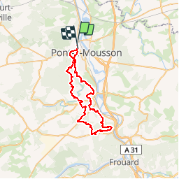

Lengte
47 km

Max. hoogte
347 m

Positief hoogteverschil
935 m
Km-Effort
59 km

Min. hoogte
175 m

Negatief hoogteverschil
931 m
Boucle
Neen
Datum van aanmaak :
2019-02-24 19:56:36.956
Laatste wijziging :
2019-03-02 07:33:17.164
--
Moeilijkheid : Onbekend

Gratisgps-wandelapplicatie
 SityTrail
IGN / Geografische instituten
SityTrail Plus
De wereld gaat voor u open
Over ons
Tocht Mountainbike van 47 km beschikbaar op Grand Est, Meurthe-et-Moselle, Pont-à-Mousson. Deze tocht wordt voorgesteld door PhilippeC54.
Plaatsbepaling
Land:
France
Regio :
Grand Est
Departement/Provincie :
Meurthe-et-Moselle
Gemeente :
Pont-à-Mousson
Locatie:
Unknown
Vertrek:(Dec)
Vertrek:(UTM)
282947 ; 5422002 (32U) N.
Opmerkingen