


balazuc 2

Coux
Gebruiker

Lengte
9,7 km

Max. hoogte
227 m

Positief hoogteverschil
229 m
Km-Effort
12,8 km

Min. hoogte
129 m

Negatief hoogteverschil
254 m
Boucle
Neen
Datum van aanmaak :
2019-02-26 09:52:01.432
Laatste wijziging :
2019-02-27 10:33:17.896
2h36
Moeilijkheid : Gemakkelijk

Gratisgps-wandelapplicatie
 SityTrail
IGN / Geografische instituten
SityTrail Plus
De wereld gaat voor u open
Over ons
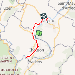
Tocht Trail van 9,7 km beschikbaar op Auvergne-Rhône-Alpes, Ardèche, Chauzon. Deze tocht wordt voorgesteld door Coux.
Plaatsbepaling
Land:
France
Regio :
Auvergne-Rhône-Alpes
Departement/Provincie :
Ardèche
Gemeente :
Chauzon
Locatie:
Unknown
Vertrek:(Dec)
Vertrek:(UTM)
607960 ; 4927549 (31T) N.
Opmerkingen