


Footing Moult 3

yannick-p
Gebruiker

Lengte
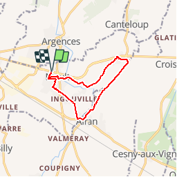
9,5 km

Max. hoogte
48 m

Positief hoogteverschil
64 m
Km-Effort
10,3 km

Min. hoogte
19 m

Negatief hoogteverschil
65 m
Boucle
Ja
Datum van aanmaak :
2019-03-18 13:46:58.627
Laatste wijziging :
2019-03-18 14:10:42.643
45m
Moeilijkheid : Gemakkelijk

Gratisgps-wandelapplicatie
 SityTrail
IGN / Geografische instituten
SityTrail Plus
De wereld gaat voor u open
Over ons
Tocht Lopen van 9,5 km beschikbaar op Normandië, Calvados, Moult-Chicheboville. Deze tocht wordt voorgesteld door yannick-p.
Plaatsbepaling
Land:
France
Regio :
Normandië
Departement/Provincie :
Calvados
Gemeente :
Moult-Chicheboville
Locatie:
Moult
Vertrek:(Dec)
Vertrek:(UTM)
706612 ; 5444325 (30U) N.
Opmerkingen