


20 mars 2019

randolea
Gebruiker

Lengte
17,1 km

Max. hoogte
300 m

Positief hoogteverschil
252 m
Km-Effort
20 km

Min. hoogte
180 m

Negatief hoogteverschil
252 m
Boucle
Ja
Datum van aanmaak :
2019-03-20 13:27:15.009
Laatste wijziging :
2019-03-20 17:49:58.416
3h14
Moeilijkheid : Gemakkelijk

Gratisgps-wandelapplicatie
 SityTrail
IGN / Geografische instituten
SityTrail Plus
De wereld gaat voor u open
Over ons
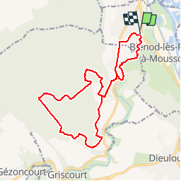
Tocht Mountainbike van 17,1 km beschikbaar op Grand Est, Meurthe-et-Moselle, Blénod-lès-Pont-à-Mousson. Deze tocht wordt voorgesteld door randolea.
Plaatsbepaling
Land:
France
Regio :
Grand Est
Departement/Provincie :
Meurthe-et-Moselle
Gemeente :
Blénod-lès-Pont-à-Mousson
Locatie:
Unknown
Vertrek:(Dec)
Vertrek:(UTM)
283875 ; 5418411 (32U) N.
Opmerkingen