


lucey

PhilippeC54
Gebruiker
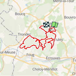

Lengte
39 km

Max. hoogte
383 m

Positief hoogteverschil
784 m
Km-Effort
50 km

Min. hoogte
248 m

Negatief hoogteverschil
783 m
Boucle
Ja
Datum van aanmaak :
2019-04-22 06:07:09.179
Laatste wijziging :
2019-04-22 09:41:33.449
3h26
Moeilijkheid : Heel gemakkelijk

Gratisgps-wandelapplicatie
 SityTrail
IGN / Geografische instituten
SityTrail Plus
De wereld gaat voor u open
Over ons
Tocht Mountainbike van 39 km beschikbaar op Grand Est, Meurthe-et-Moselle, Lucey. Deze tocht wordt voorgesteld door PhilippeC54.
Plaatsbepaling
Land:
France
Regio :
Grand Est
Departement/Provincie :
Meurthe-et-Moselle
Gemeente :
Lucey
Locatie:
Unknown
Vertrek:(Dec)
Vertrek:(UTM)
708436 ; 5400216 (31U) N.
Opmerkingen