


7 mai 2019 jour 7

dudu85
Gebruiker

Lengte
30 km

Max. hoogte
65 m

Positief hoogteverschil
394 m
Km-Effort
35 km

Min. hoogte
12 m

Negatief hoogteverschil
387 m
Boucle
Neen
Datum van aanmaak :
2019-04-25 17:46:36.668
Laatste wijziging :
2019-04-29 04:47:45.373
46m
Moeilijkheid : Gemakkelijk

Gratisgps-wandelapplicatie
 SityTrail
IGN / Geografische instituten
SityTrail Plus
De wereld gaat voor u open
Over ons
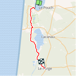
Tocht Stappen van 30 km beschikbaar op Nieuw-Aquitanië, Gironde, Carcans. Deze tocht wordt voorgesteld door dudu85.
Beschrijving
Départ Maubuisson direction Le Porge en longeant le lac de Lacanau
Distance cumulée 187,1km
Plaatsbepaling
Land:
France
Regio :
Nieuw-Aquitanië
Departement/Provincie :
Gironde
Gemeente :
Carcans
Locatie:
Unknown
Vertrek:(Dec)
Vertrek:(UTM)
646375 ; 4992238 (30T) N.
Opmerkingen