2013-07-22 Rando Autour de St Lô (Lundi)

jchezlemas
Gebruiker

Lengte
15,9 km

Max. hoogte
148 m

Positief hoogteverschil
235 m
Km-Effort
19 km

Min. hoogte
64 m

Negatief hoogteverschil
234 m
Boucle
Ja
Datum van aanmaak :
2014-12-10 00:00:00.0
Laatste wijziging :
2014-12-10 00:00:00.0
4h08
Moeilijkheid : Medium

Gratisgps-wandelapplicatie
 SityTrail
IGN / Geografische instituten
SityTrail Plus
De wereld gaat voor u open
Over ons
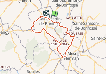
Tocht Stappen van 15,9 km beschikbaar op Normandië, Manche, Saint-Martin-de-Bonfossé. Deze tocht wordt voorgesteld door jchezlemas.
Plaatsbepaling
Land:
France
Regio :
Normandië
Departement/Provincie :
Manche
Gemeente :
Saint-Martin-de-Bonfossé
Locatie:
Unknown
Vertrek:(Dec)
Vertrek:(UTM)
633760 ; 5435023 (30U) N.
Opmerkingen