


03-05-2019 3 journée 30,2km

dudu85
Gebruiker
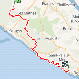

Lengte
26 km

Max. hoogte
26 m

Positief hoogteverschil
214 m
Km-Effort
29 km

Min. hoogte
2 m

Negatief hoogteverschil
214 m
Boucle
Neen
Datum van aanmaak :
2019-05-03 07:38:40.0
Laatste wijziging :
2019-05-03 14:59:37.463
6h36
Moeilijkheid : Onbekend

Gratisgps-wandelapplicatie
 SityTrail
IGN / Geografische instituten
SityTrail Plus
De wereld gaat voor u open
Over ons
Tocht Stappen van 26 km beschikbaar op Nieuw-Aquitanië, Charente-Maritime, Les Mathes. Deze tocht wordt voorgesteld door dudu85.
Beschrijving
Randonnée mixte foret GR4 et bord de mer.
Départ de Dirée commune d’Alvert) Arrivée Royal
Plaatsbepaling
Land:
France
Regio :
Nieuw-Aquitanië
Departement/Provincie :
Charente-Maritime
Gemeente :
Les Mathes
Locatie:
Unknown
Vertrek:(Dec)
Vertrek:(UTM)
641963 ; 5065410 (30T) N.
Opmerkingen