


LA BIGNETTE

UDGI54
Gebruiker
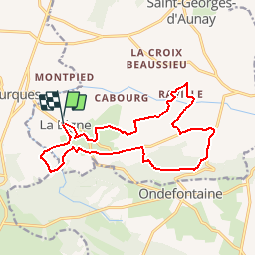

Lengte
15,1 km

Max. hoogte
259 m

Positief hoogteverschil
317 m
Km-Effort
19,4 km

Min. hoogte
138 m

Negatief hoogteverschil
319 m
Boucle
Ja
Datum van aanmaak :
2019-05-08 13:54:23.818
Laatste wijziging :
2019-05-08 14:05:54.604
4h09
Moeilijkheid : Moeilijk

Gratisgps-wandelapplicatie
 SityTrail
IGN / Geografische instituten
SityTrail Plus
De wereld gaat voor u open
Over ons
Tocht Stappen van 15,1 km beschikbaar op Normandië, Calvados, Seulline. Deze tocht wordt voorgesteld door UDGI54.
Plaatsbepaling
Land:
France
Regio :
Normandië
Departement/Provincie :
Calvados
Gemeente :
Seulline
Locatie:
La Bigne
Vertrek:(Dec)
Vertrek:(UTM)
666430 ; 5431324 (30U) N.
Opmerkingen