


GTDV-J2

PhilippeC54
Gebruiker

Lengte
41 km

Max. hoogte
2469 m

Positief hoogteverschil
1721 m
Km-Effort
63 km

Min. hoogte
1246 m

Negatief hoogteverschil
1537 m
Boucle
Neen
Datum van aanmaak :
2019-05-09 15:14:28.567
Laatste wijziging :
2019-05-09 15:14:28.567
--
Moeilijkheid : Onbekend

Gratisgps-wandelapplicatie
 SityTrail
IGN / Geografische instituten
SityTrail Plus
De wereld gaat voor u open
Over ons
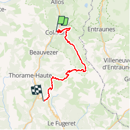
Tocht Mountainbike van 41 km beschikbaar op Provence-Alpes-Côte d'Azur, Alpes-de-Haute-Provence, Colmars. Deze tocht wordt voorgesteld door PhilippeC54.
Plaatsbepaling
Land:
France
Regio :
Provence-Alpes-Côte d'Azur
Departement/Provincie :
Alpes-de-Haute-Provence
Gemeente :
Colmars
Locatie:
Unknown
Vertrek:(Dec)
Vertrek:(UTM)
310259 ; 4894789 (32T) N.
Opmerkingen