


Cogles

CANON2
Gebruiker
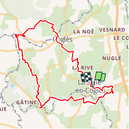

Lengte
19,1 km

Max. hoogte
127 m

Positief hoogteverschil
199 m
Km-Effort
22 km

Min. hoogte
87 m

Negatief hoogteverschil
199 m
Boucle
Ja
Datum van aanmaak :
2019-05-15 13:09:37.48
Laatste wijziging :
2019-05-15 13:09:37.578
4h47
Moeilijkheid : Medium

Gratisgps-wandelapplicatie
 SityTrail
IGN / Geografische instituten
SityTrail Plus
De wereld gaat voor u open
Over ons
Tocht Stappen van 19,1 km beschikbaar op Bretagne, Ille-et-Vilaine, Les Portes du Coglais. Deze tocht wordt voorgesteld door CANON2.
Plaatsbepaling
Land:
France
Regio :
Bretagne
Departement/Provincie :
Ille-et-Vilaine
Gemeente :
Les Portes du Coglais
Locatie:
Unknown
Vertrek:(Dec)
Vertrek:(UTM)
622497 ; 5366238 (30U) N.
Opmerkingen