


Chaumont en vexin - roche guyon

medhy60
Gebruiker
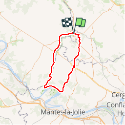

Lengte
72 km

Max. hoogte
178 m

Positief hoogteverschil
841 m
Km-Effort
83 km

Min. hoogte
20 m

Negatief hoogteverschil
841 m
Boucle
Ja
Datum van aanmaak :
2014-12-10 00:00:00.0
Laatste wijziging :
2014-12-10 00:00:00.0
4h46
Moeilijkheid : Medium

Gratisgps-wandelapplicatie
 SityTrail
IGN / Geografische instituten
SityTrail Plus
De wereld gaat voor u open
Over ons
Tocht Fiets van 72 km beschikbaar op Normandië, Eure, Gisors. Deze tocht wordt voorgesteld door medhy60.


Plaatsbepaling
Land:
France
Regio :
Normandië
Departement/Provincie :
Eure
Gemeente :
Gisors
Locatie:
Unknown
Vertrek:(Dec)
Vertrek:(UTM)
411088 ; 5459221 (31U) N.
Opmerkingen