![](/images/other/stat-length.png)
![Tocht Stappen Guillaumes - 20190512 CAF traversée Daluis Pont des Roberts - Pont des Chaudans par Villetalle, Amen, Roua, Liouc - Photo](https://media.geolcdn.com/t/1900/400/ext.pjpeg?maxdim=2&url=https%3A%2F%2Fstatic1.geolcdn.com%2Fsiteimages%2Fupload%2Ffiles%2F1553511878bg_sport_marche.png)
20190512 CAF traversée Daluis Pont des Roberts - Pont des Chaudans par Villetalle, Amen, Roua, Liouc
motardes04
Gebruiker
![Lengte](/images/other/stat-length.png)
![Max. hoogte](https://static1.geolcdn.com/siteimages/upload/files/1508320355ic_sort_altitude_max_24dp.png)
![Positief hoogteverschil](https://static1.geolcdn.com/siteimages/upload/files/1508320355ic_sort_den_pos_24dp.png)
![Km-Effort](/images/other/stat-length.png)
![Min. hoogte](https://static1.geolcdn.com/siteimages/upload/files/1508320355ic_sort_altitude_min_24dp.png)
![Negatief hoogteverschil](https://static1.geolcdn.com/siteimages/upload/files/1508320355ic_sort_den_neg_24dp.png)
![Boucle](https://static1.geolcdn.com/siteimages/upload/files/16400158638029165_repeat_loop_refresh_sync_direction_icon.png)
![Stappen](https://static1.geolcdn.com/sitytour/trail-icons/101.png)
7h51
Moeilijkheid : Zeer moeilijk
![Scan deze QR-code om de tocht te openen in de SityTrail-applicatie](https://capi.geolives.com/qq0zvz2zws4bq2lad0pu/sitytour/trails/2080458/qr.png?size=200)
Gratisgps-wandelapplicatie
Over ons
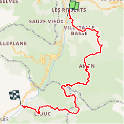
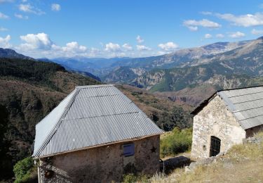
Tocht Stappen van 19,9 km beschikbaar op Provence-Alpes-Côte d'Azur, Alpes-Maritimes, Guillaumes. Deze tocht wordt voorgesteld door motardes04.
Beschrijving
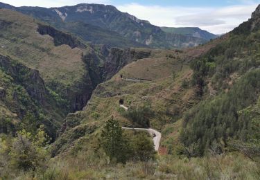
ATTENTION !! le circuit Randoxygène Boucle d'Amen est actuellement fermé entre les balises 111-112 et 112-115. Vérifiez les informations avant de planifier votre itinéraire
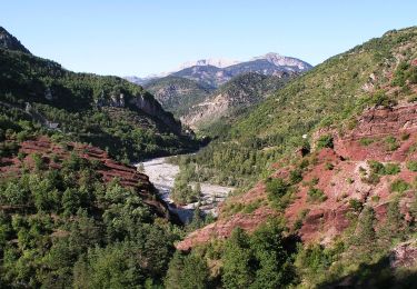
En raison de cette fermeture, nous avons organisé une navette de voitures pour réaliser une "traversée" (longitudinale) des gorges de Daluis.
Paysages féériques assurés.
ATTENTION !!!
Le sentier figurant sur les anciennes cartes en tant que PR via le vallon de Roua (direction balise 110) n'existe plus malgré la pancarte toujours présente à l'intersection balise 140. L'entretien du tracé semble avoir été complètement abandonné.
Nous avons déployé des trésors de recherche de marques, cairns et autres passages (de sangliers plus que d'humains) pour rejoindre la bergerie de Roua puis rattraper la piste menant au col de Roua (au demeurant via un accès privé interdit).
Le terrain étant escarpé, et l'ensemble en proximité de barres rocheuses, sans marquage, l'itinéraire qui figure sur la dernière carte en "sentier non balisé" est objectivement DANGEREUX et doit être évité en passant par la piste direction col de Roua.
Plaatsbepaling
Opmerkingen
Wandeltochten in de omgeving
![Tocht Te voet Guillaumes - Gorges de Daluis - Photo](https://media.geolcdn.com/t/375/260/ext.jpg?maxdim=2&url=https%3A%2F%2Fmedia.geolcdn.com%2Ff%2Fcf6f6166-06c7-4fb4-b3e6-a1ea2ecf5d7a.jpeg)
![Te voet Te voet](https://static1.geolcdn.com/sitytour/trail-icons/100.png)
Te voet
![](/images/other/stat-length.png)
![](https://static1.geolcdn.com/siteimages/upload/files/16400158638029165_repeat_loop_refresh_sync_direction_icon.png)
![Tocht Te voet Péone - Circuit de Septenne - Photo](https://media.geolcdn.com/t/375/260/ext.jpg?maxdim=2&url=https%3A%2F%2Fmedia.geolcdn.com%2Ff%2Fece6b3bc-3f52-4b23-955d-de7c74062137.jpeg)
![Te voet Te voet](https://static1.geolcdn.com/sitytour/trail-icons/100.png)
Te voet
![](/images/other/stat-length.png)
![](https://static1.geolcdn.com/siteimages/upload/files/16400158638029165_repeat_loop_refresh_sync_direction_icon.png)
![Tocht Te voet Sauze - Hameaux de Sauze - Photo](https://media.geolcdn.com/t/375/260/ext.jpg?maxdim=2&url=https%3A%2F%2Fmedia.geolcdn.com%2Ff%2F8de1e0fb-d754-4ba0-84e6-05cab893c487.jpeg)
![Te voet Te voet](https://static1.geolcdn.com/sitytour/trail-icons/100.png)
Te voet
![](/images/other/stat-length.png)
![](https://static1.geolcdn.com/siteimages/upload/files/16400158638029165_repeat_loop_refresh_sync_direction_icon.png)
![Tocht Stappen Daluis - Gorges de Daluis - Photo](https://media.geolcdn.com/t/375/260/ext.jpg?maxdim=2&url=https%3A%2F%2Fstatic1.geolcdn.com%2Fsiteimages%2Fupload%2Ffiles%2F1553511878bg_sport_marche.png)
![Stappen Stappen](https://static1.geolcdn.com/sitytour/trail-icons/101.png)
Stappen
![](/images/other/stat-length.png)
![](https://static1.geolcdn.com/siteimages/upload/files/16400158638029165_repeat_loop_refresh_sync_direction_icon.png)
![Tocht Stappen Daluis - Gorges de Daluis - Photo](https://media.geolcdn.com/t/375/260/ext.jpg?maxdim=2&url=https%3A%2F%2Fmedia.geolcdn.com%2Ff%2F617cb6d2-42fa-4d55-b1a3-65b3424d4778.jpg)
![Stappen Stappen](https://static1.geolcdn.com/sitytour/trail-icons/101.png)
Stappen
![](/images/other/stat-length.png)
![](https://static1.geolcdn.com/siteimages/upload/files/16400158638029165_repeat_loop_refresh_sync_direction_icon.png)
![Tocht Te voet Guillaumes - Circuit d'Amen - Photo](https://media.geolcdn.com/t/375/260/ext.jpg?maxdim=2&url=https%3A%2F%2Fmedia.geolcdn.com%2Ff%2Ffaf9e9ab-a880-4a21-b636-bc915b90fa63.jpeg)
![Te voet Te voet](https://static1.geolcdn.com/sitytour/trail-icons/100.png)
Te voet
![](/images/other/stat-length.png)
![](https://static1.geolcdn.com/siteimages/upload/files/16400158638029165_repeat_loop_refresh_sync_direction_icon.png)
![Tocht Stappen Guillaumes - Circuit d'Amen - Photo](https://media.geolcdn.com/t/375/260/ext.jpg?maxdim=2&url=https%3A%2F%2Fmedia.geolcdn.com%2Ff%2F8ff75953-4da4-44e8-83de-0722fa715c40.jpg)
![Stappen Stappen](https://static1.geolcdn.com/sitytour/trail-icons/101.png)
Stappen
![](/images/other/stat-length.png)
![](https://static1.geolcdn.com/siteimages/upload/files/16400158638029165_repeat_loop_refresh_sync_direction_icon.png)
![Tocht Stappen Daluis - Gorges de Daluis - Photo](https://media.geolcdn.com/t/375/260/ext.jpg?maxdim=2&url=https%3A%2F%2Fmedia.geolcdn.com%2Ff%2Fd299ffe3-5c50-4ecd-aba1-806ccfd47d3d.jpg)
![Stappen Stappen](https://static1.geolcdn.com/sitytour/trail-icons/101.png)
Stappen
![](/images/other/stat-length.png)
![](https://static1.geolcdn.com/siteimages/upload/files/16400158638029165_repeat_loop_refresh_sync_direction_icon.png)
![Tocht Stappen Daluis - Gorges du Daluis - Photo](https://media.geolcdn.com/t/375/260/ext.jpg?maxdim=2&url=https%3A%2F%2Fmedia.geolcdn.com%2Ff%2F38db2acd-ddab-438c-8fd8-215a6512b64e.jpg)
![Stappen Stappen](https://static1.geolcdn.com/sitytour/trail-icons/101.png)
Stappen
![](/images/other/stat-length.png)
![](https://static1.geolcdn.com/siteimages/upload/files/16400158638029165_repeat_loop_refresh_sync_direction_icon.png)