


Redu-Maissin

pierlan
Gebruiker
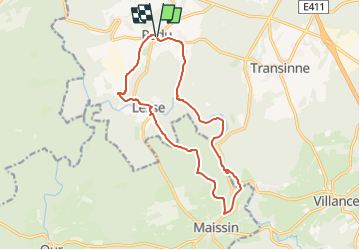

Lengte
13,6 km

Max. hoogte
389 m

Positief hoogteverschil
311 m
Km-Effort
17,8 km

Min. hoogte
262 m

Negatief hoogteverschil
313 m
Boucle
Ja
Datum van aanmaak :
2019-05-14 14:25:36.081
Laatste wijziging :
2024-09-02 18:51:34.282
4h02
Moeilijkheid : Moeilijk

Gratisgps-wandelapplicatie
 SityTrail
IGN / Geografische instituten
SityTrail Plus
De wereld gaat voor u open
Over ons
Tocht Stappen van 13,6 km beschikbaar op Wallonië, Luxemburg, Libin. Deze tocht wordt voorgesteld door pierlan.
Plaatsbepaling
Land:
Belgium
Regio :
Wallonië
Departement/Provincie :
Luxemburg
Gemeente :
Libin
Locatie:
Redu
Vertrek:(Dec)
Vertrek:(UTM)
654792 ; 5541697 (31U) N.
Opmerkingen