Angleur/esneux GR57

Ko-Rando
Gebruiker
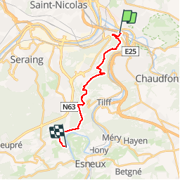

Lengte
13,9 km

Max. hoogte
269 m

Positief hoogteverschil
393 m
Km-Effort
19 km

Min. hoogte
63 m

Negatief hoogteverschil
341 m
Boucle
Neen
Datum van aanmaak :
2019-05-27 11:54:50.333
Laatste wijziging :
2019-05-27 18:13:15.001
3h07
Moeilijkheid : Gemakkelijk

Gratisgps-wandelapplicatie
 SityTrail
IGN / Geografische instituten
SityTrail Plus
De wereld gaat voor u open
Over ons
Tocht Stappen van 13,9 km beschikbaar op Wallonië, Luik, Luik. Deze tocht wordt voorgesteld door Ko-Rando.
Plaatsbepaling
Land:
Belgium
Regio :
Wallonië
Departement/Provincie :
Luik
Gemeente :
Luik
Locatie:
Angleur
Vertrek:(Dec)
Vertrek:(UTM)
683903 ; 5609975 (31U) N.
Opmerkingen