


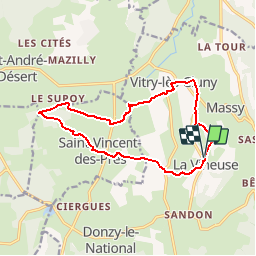
Boucle La Vineuse

jeanboulay
Gebruiker

Lengte
13,8 km

Max. hoogte
370 m

Positief hoogteverschil
317 m
Km-Effort
18 km

Min. hoogte
227 m

Negatief hoogteverschil
317 m
Boucle
Ja
Datum van aanmaak :
2019-05-31 08:58:23.045
Laatste wijziging :
2019-05-31 08:59:37.575
3h51
Moeilijkheid : Moeilijk

Gratisgps-wandelapplicatie
 SityTrail
IGN / Geografische instituten
SityTrail Plus
De wereld gaat voor u open
Over ons
Tocht Stappen van 13,8 km beschikbaar op Bourgondië-Franche-Comté, Saône-et-Loire, La Vineuse sur Fregande. Deze tocht wordt voorgesteld door jeanboulay.
Plaatsbepaling
Land:
France
Regio :
Bourgondië-Franche-Comté
Departement/Provincie :
Saône-et-Loire
Gemeente :
La Vineuse sur Fregande
Locatie:
Unknown
Vertrek:(Dec)
Vertrek:(UTM)
622608 ; 5147837 (31T) N.
Opmerkingen