


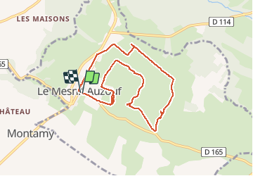
mesnil auzouf

gr1346
Gebruiker

Lengte
8,2 km

Max. hoogte
305 m

Positief hoogteverschil
103 m
Km-Effort
9,5 km

Min. hoogte
249 m

Negatief hoogteverschil
101 m
Boucle
Ja
Datum van aanmaak :
2019-05-31 07:10:35.257
Laatste wijziging :
2019-05-31 09:32:20.381
2h17
Moeilijkheid : Heel gemakkelijk

Gratisgps-wandelapplicatie
 SityTrail
IGN / Geografische instituten
SityTrail Plus
De wereld gaat voor u open
Over ons
Tocht Stappen van 8,2 km beschikbaar op Normandië, Calvados, Dialan sur Chaîne. Deze tocht wordt voorgesteld door gr1346.
Plaatsbepaling
Land:
France
Regio :
Normandië
Departement/Provincie :
Calvados
Gemeente :
Dialan sur Chaîne
Locatie:
Le Mesnil-Auzouf
Vertrek:(Dec)
Vertrek:(UTM)
664532 ; 5427640 (30U) N.
Opmerkingen