


Ramelot - Clavier - Hoyoux - Modave - Ramelot

bncg
Gebruiker
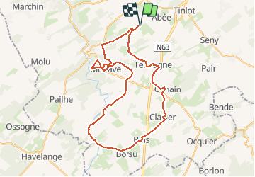

Lengte
33 km

Max. hoogte
320 m

Positief hoogteverschil
375 m
Km-Effort
38 km

Min. hoogte
202 m

Negatief hoogteverschil
375 m
Boucle
Ja
Datum van aanmaak :
2014-12-10 00:00:00.0
Laatste wijziging :
2014-12-10 00:00:00.0
2h11
Moeilijkheid : Gemakkelijk

Gratisgps-wandelapplicatie
 SityTrail
IGN / Geografische instituten
SityTrail Plus
De wereld gaat voor u open
Over ons
Tocht Fiets van 33 km beschikbaar op Wallonië, Luik, Tinlot. Deze tocht wordt voorgesteld door bncg.
Plaatsbepaling
Land:
Belgium
Regio :
Wallonië
Departement/Provincie :
Luik
Gemeente :
Tinlot
Locatie:
Ramelot
Vertrek:(Dec)
Vertrek:(UTM)
665761 ; 5593288 (31U) N.
Opmerkingen