


GROIX J 2

Laurent53
Gebruiker

Lengte
21 km

Max. hoogte
48 m

Positief hoogteverschil
308 m
Km-Effort
25 km

Min. hoogte
0 m

Negatief hoogteverschil
308 m
Boucle
Ja
Datum van aanmaak :
2019-06-03 16:13:17.594
Laatste wijziging :
2019-06-03 16:14:54.466
5h31
Moeilijkheid : Medium

Gratisgps-wandelapplicatie
 SityTrail
IGN / Geografische instituten
SityTrail Plus
De wereld gaat voor u open
Over ons
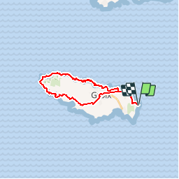
Tocht Stappen van 21 km beschikbaar op Bretagne, Morbihan, Groix. Deze tocht wordt voorgesteld door Laurent53.
Plaatsbepaling
Land:
France
Regio :
Bretagne
Departement/Provincie :
Morbihan
Gemeente :
Groix
Locatie:
Unknown
Vertrek:(Dec)
Vertrek:(UTM)
468610 ; 5275502 (30T) N.
Opmerkingen