


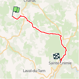
St Guilhem 6 - Le Gazy à St Enimie

mysterdub
Gebruiker

Lengte
19,4 km

Max. hoogte
974 m

Positief hoogteverschil
268 m
Km-Effort
24 km

Min. hoogte
475 m

Negatief hoogteverschil
650 m
Boucle
Neen
Datum van aanmaak :
2019-06-04 06:39:00.244
Laatste wijziging :
2019-07-05 20:43:48.965
5h46
Moeilijkheid : Heel gemakkelijk

Gratisgps-wandelapplicatie
 SityTrail
IGN / Geografische instituten
SityTrail Plus
De wereld gaat voor u open
Over ons
Tocht Stappen van 19,4 km beschikbaar op Occitanië, Lozère, Chanac. Deze tocht wordt voorgesteld door mysterdub.
Plaatsbepaling
Land:
France
Regio :
Occitanië
Departement/Provincie :
Lozère
Gemeente :
Chanac
Locatie:
Chanac
Vertrek:(Dec)
Vertrek:(UTM)
524131 ; 4920812 (31T) N.
Opmerkingen