Tocht Stappen Angoustrine-Villeneuve-des-Escaldes - Randonnee-Pic-de-Carlit-2921m-Mariano-le-09-09-2013 - Photo

Randonnee-Pic-de-Carlit-2921m-Mariano-le-09-09-2013

 UDGI54
UDGI54

Gebruiker

© OpenStreetMap contributors
Lengte
Lengte
13,4 km
Max. hoogte
Max. hoogte
2885 m
Positief hoogteverschil
889 m
Km-Effort
Km-Effort  
25 km
Min. hoogte
Min. hoogte
2038 m
Negatief hoogteverschil
887 m
Boucle
Boucle
Ja
Datum van aanmaak :
2019-06-11 07:21:55.866
Laatste wijziging :
2019-06-11 07:26:31.929

(1 Bericht)

Stappen
Stappen
5h04
Moeilijkheid : Zeer moeilijk

Scan deze QR-code om de tocht te openen in de SityTrail-applicatie

Gratisgps-wandelapplicatie

Logo SityTrail SityTrail

IGN / Geografische instituten

SityTrail uit de App Store downloaden SityTrail uit Google Play downloaden

Logo SityTrail SityTrail Plus

De wereld gaat voor u open

SityTrail uit de App Store downloaden SityTrail uit Google Play downloaden SityTrail op Huawei AppGallery downloaden

Over ons

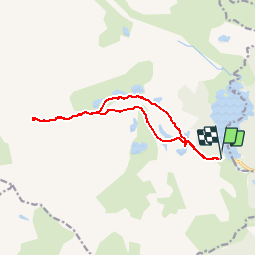
Tocht Stappen van 13,4 km beschikbaar op Occitanië, Pyrénées-Orientales, Angoustrine-Villeneuve-des-Escaldes. Deze tocht wordt voorgesteld door UDGI54.

Hoogteprofiel

POI's

POI Angoustrine-Villeneuve-des-Escaldes - Refuge-Bornes-Hores-2033m - Photo
UDGI54
ANGOUSTRINE-VILLENEUVE-DES-ESCALDES 
POI Angoustrine-Villeneuve-des-Escaldes - Pic-Carlit-2921m - Photo
UDGI54
ANGOUSTRINE-VILLENEUVE-DES-ESCALDES 
POI Angoustrine-Villeneuve-des-Escaldes - Lac-Noir-2140m - Photo
UDGI54
ANGOUSTRINE-VILLENEUVE-DES-ESCALDES 
POI Angoustrine-Villeneuve-des-Escaldes - Lac-Gombau-2300m - Photo
UDGI54
ANGOUSTRINE-VILLENEUVE-DES-ESCALDES 
POI Angoustrine-Villeneuve-des-Escaldes - Lac-des-Dugues-2230m - Photo
UDGI54
ANGOUSTRINE-VILLENEUVE-DES-ESCALDES 
POI Angoustrine-Villeneuve-des-Escaldes - Lac-de-Sobirans-2360m - Photo
UDGI54
ANGOUSTRINE-VILLENEUVE-DES-ESCALDES 
POI Angoustrine-Villeneuve-des-Escaldes - Lac-de-la-Comasse-2160m - Photo
UDGI54
ANGOUSTRINE-VILLENEUVE-DES-ESCALDES 
POI Angoustrine-Villeneuve-des-Escaldes - Lac-de-Castella-2300m - Photo
UDGI54
ANGOUSTRINE-VILLENEUVE-DES-ESCALDES 
POI Angoustrine-Villeneuve-des-Escaldes - Lac- de-Trebens-2320m - Photo
UDGI54
ANGOUSTRINE-VILLENEUVE-DES-ESCALDES 
POI Les Angles - Lac- Bouillouses-2017m - Photo
UDGI54
POI Angoustrine-Villeneuve-des-Escaldes - Etang-Sec-2160m - Photo
UDGI54
ANGOUSTRINE-VILLENEUVE-DES-ESCALDES 
POI Angoustrine-Villeneuve-des-Escaldes - Etang-Long-2200m - Photo
UDGI54
ANGOUSTRINE-VILLENEUVE-DES-ESCALDES 
POI Angoustrine-Villeneuve-des-Escaldes - Etang-Llat-2180m - Photo
UDGI54
ANGOUSTRINE-VILLENEUVE-DES-ESCALDES 
POI Angoustrine-Villeneuve-des-Escaldes - Etang-de-la-Vive-2137m - Photo
UDGI54
ANGOUSTRINE-VILLENEUVE-DES-ESCALDES 
POI Angoustrine-Villeneuve-des-Escaldes - Depart-2017m - Photo
UDGI54
ANGOUSTRINE-VILLENEUVE-DES-ESCALDES 
POI Angoustrine-Villeneuve-des-Escaldes - Col-de-Carlit-2900m - Photo
UDGI54
ANGOUSTRINE-VILLENEUVE-DES-ESCALDES 
POI Les Angles - Chalet-Refuge - Photo
UDGI54
LES ANGLES 
POI Angoustrine-Villeneuve-des-Escaldes - Bifurcation-2370m - Photo
UDGI54
ANGOUSTRINE-VILLENEUVE-DES-ESCALDES 
POI Angoustrine-Villeneuve-des-Escaldes - Bifurcation-2300m - Photo
UDGI54
ANGOUSTRINE-VILLENEUVE-DES-ESCALDES 
POI Angoustrine-Villeneuve-des-Escaldes - Bifurcation-2240m - Photo
UDGI54
ANGOUSTRINE-VILLENEUVE-DES-ESCALDES 
POI Angoustrine-Villeneuve-des-Escaldes - Bifurcation-2230m - Photo
UDGI54
ANGOUSTRINE-VILLENEUVE-DES-ESCALDES 
POI Angoustrine-Villeneuve-des-Escaldes - Bifurcation-2150m - Photo
UDGI54
ANGOUSTRINE-VILLENEUVE-DES-ESCALDES 

Plaatsbepaling

Land:
France
Regio :
Occitanië
Departement/Provincie :
Pyrénées-Orientales
Gemeente :
Angoustrine-Villeneuve-des-Escaldes
Locatie:
Unknown
Vertrek:(Dec)
Vertrek:(UTM)
417598 ; 4712439 (31T) N.

Opmerkingen

Gelieve in te loggen om een commentaar of een beoordeling achter te laten


Sluiten
Mijn abonnementen