


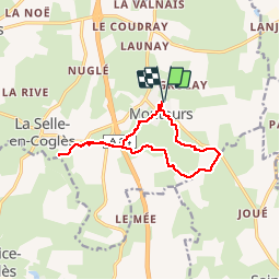
montours pontbesnard chênesec11km

coglais
Gebruiker

Lengte
11,3 km

Max. hoogte
166 m

Positief hoogteverschil
136 m
Km-Effort
13,1 km

Min. hoogte
102 m

Negatief hoogteverschil
136 m
Boucle
Ja
Datum van aanmaak :
2019-06-11 07:15:02.545
Laatste wijziging :
2019-06-12 09:27:20.255
2h30
Moeilijkheid : Medium

Gratisgps-wandelapplicatie
 SityTrail
IGN / Geografische instituten
SityTrail Plus
De wereld gaat voor u open
Over ons
Tocht Noords wandelen van 11,3 km beschikbaar op Bretagne, Ille-et-Vilaine, Les Portes du Coglais. Deze tocht wordt voorgesteld door coglais.
Plaatsbepaling
Land:
France
Regio :
Bretagne
Departement/Provincie :
Ille-et-Vilaine
Gemeente :
Les Portes du Coglais
Locatie:
Montours
Vertrek:(Dec)
Vertrek:(UTM)
625207 ; 5367055 (30U) N.
Opmerkingen