


les cavalquiches au restau

thle
Gebruiker
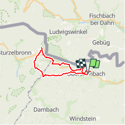

Lengte
17,9 km

Max. hoogte
330 m

Positief hoogteverschil
346 m
Km-Effort
23 km

Min. hoogte
239 m

Negatief hoogteverschil
349 m
Boucle
Ja
Datum van aanmaak :
2019-06-20 13:56:36.096
Laatste wijziging :
2019-06-20 14:11:39.385
1h11
Moeilijkheid : Gemakkelijk

Gratisgps-wandelapplicatie
 SityTrail
IGN / Geografische instituten
SityTrail Plus
De wereld gaat voor u open
Over ons
Tocht Paardrijden van 17,9 km beschikbaar op Grand Est, Bas-Rhin, Obersteinbach. Deze tocht wordt voorgesteld door thle.
Plaatsbepaling
Land:
France
Regio :
Grand Est
Departement/Provincie :
Bas-Rhin
Gemeente :
Obersteinbach
Locatie:
Unknown
Vertrek:(Dec)
Vertrek:(UTM)
404326 ; 5432285 (32U) N.
Opmerkingen