


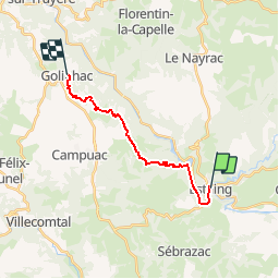
ESTAING - GOLINHAC

gallo
Gebruiker

Lengte
14,6 km

Max. hoogte
665 m

Positief hoogteverschil
593 m
Km-Effort
21 km

Min. hoogte
310 m

Negatief hoogteverschil
273 m
Boucle
Neen
Datum van aanmaak :
2019-06-21 12:11:12.253
Laatste wijziging :
2019-06-21 12:11:53.324
4h40
Moeilijkheid : Zeer moeilijk

Gratisgps-wandelapplicatie
 SityTrail
IGN / Geografische instituten
SityTrail Plus
De wereld gaat voor u open
Over ons
Tocht Stappen van 14,6 km beschikbaar op Occitanië, Aveyron, Estaing. Deze tocht wordt voorgesteld door gallo.
Plaatsbepaling
Land:
France
Regio :
Occitanië
Departement/Provincie :
Aveyron
Gemeente :
Estaing
Locatie:
Unknown
Vertrek:(Dec)
Vertrek:(UTM)
474023 ; 4933462 (31T) N.
Opmerkingen