


SityTrail - DRAVEIL Pk Base de Loisirs A/R 18 Km

c.chehere
Gebruiker
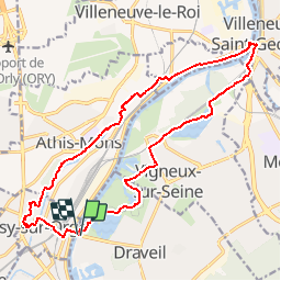

Lengte
17,8 km

Max. hoogte
85 m

Positief hoogteverschil
183 m
Km-Effort
20 km

Min. hoogte
28 m

Negatief hoogteverschil
184 m
Boucle
Ja
Datum van aanmaak :
2019-06-27 11:06:39.174
Laatste wijziging :
2019-06-27 11:07:36.585
4h28
Moeilijkheid : Gemakkelijk

Gratisgps-wandelapplicatie
 SityTrail
IGN / Geografische instituten
SityTrail Plus
De wereld gaat voor u open
Over ons
Tocht Stappen van 17,8 km beschikbaar op Île-de-France, Essonne, Draveil. Deze tocht wordt voorgesteld door c.chehere.
Beschrijving
DRAVEIL
BARRAGE ECLUSE de VIGNEUX FERMEE
Plaatsbepaling
Land:
France
Regio :
Île-de-France
Departement/Provincie :
Essonne
Gemeente :
Draveil
Locatie:
Unknown
Vertrek:(Dec)
Vertrek:(UTM)
455100 ; 5393031 (31U) N.
Opmerkingen