


VERT LE GRAND ETANGS LISSES

ALIROL
Gebruiker
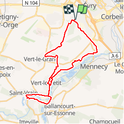

Lengte
32 km

Max. hoogte
97 m

Positief hoogteverschil
283 m
Km-Effort
36 km

Min. hoogte
45 m

Negatief hoogteverschil
283 m
Boucle
Ja
Datum van aanmaak :
2014-12-10 00:00:00.0
Laatste wijziging :
2014-12-10 00:00:00.0
2h22
Moeilijkheid : Medium

Gratisgps-wandelapplicatie
 SityTrail
IGN / Geografische instituten
SityTrail Plus
De wereld gaat voor u open
Over ons
Tocht Mountainbike van 32 km beschikbaar op Île-de-France, Essonne, Évry-Courcouronnes. Deze tocht wordt voorgesteld door ALIROL.
Beschrijving
Chemins. Très peu de routes.
Plaatsbepaling
Land:
France
Regio :
Île-de-France
Departement/Provincie :
Essonne
Gemeente :
Évry-Courcouronnes
Locatie:
Courcouronnes
Vertrek:(Dec)
Vertrek:(UTM)
456402 ; 5384362 (31U) N.
Opmerkingen