


WIiclow5

dewaeph
Gebruiker
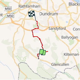

Lengte
10,6 km

Max. hoogte
532 m

Positief hoogteverschil
219 m
Km-Effort
14,3 km

Min. hoogte
86 m

Negatief hoogteverschil
466 m
Boucle
Neen
Datum van aanmaak :
2019-07-23 10:22:52.915
Laatste wijziging :
2019-07-23 15:12:09.94
4h40
Moeilijkheid : Heel gemakkelijk

Gratisgps-wandelapplicatie
 SityTrail
IGN / Geografische instituten
SityTrail Plus
De wereld gaat voor u open
Over ons
Tocht Stappen van 10,6 km beschikbaar op Onbekend, County Dublin, Onbekend. Deze tocht wordt voorgesteld door dewaeph.
Plaatsbepaling
Land:
Ireland
Regio :
Onbekend
Departement/Provincie :
County Dublin
Gemeente :
Onbekend
Locatie:
Whitechurch ED
Vertrek:(Dec)
Vertrek:(UTM)
682458 ; 5901237 (29U) N.
Opmerkingen