


Circuit no 10

phil21
Gebruiker

Lengte
21 km
Boucle
Ja
Datum van aanmaak :
2019-08-03 14:02:40.0
Laatste wijziging :
2019-08-03 16:00:23.129
1h56
Moeilijkheid : Onbekend

Gratisgps-wandelapplicatie
 SityTrail
IGN / Geografische instituten
SityTrail Plus
De wereld gaat voor u open
Over ons
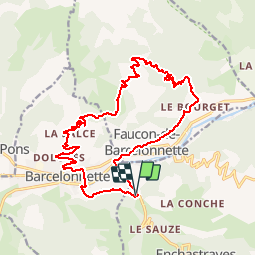
Tocht Mountainbike van 21 km beschikbaar op Provence-Alpes-Côte d'Azur, Alpes-de-Haute-Provence, Enchastrayes. Deze tocht wordt voorgesteld door phil21.
Plaatsbepaling
Land:
France
Regio :
Provence-Alpes-Côte d'Azur
Departement/Provincie :
Alpes-de-Haute-Provence
Gemeente :
Enchastrayes
Locatie:
Unknown
Vertrek:(Dec)
Vertrek:(UTM)
314821 ; 4916927 (32T) N.
Opmerkingen