


Vaux sur aure jardi public 10 kms 2019

aubinjoel
Gebruiker
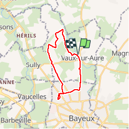

Lengte
10,1 km

Max. hoogte
63 m

Positief hoogteverschil
70 m
Km-Effort
11 km

Min. hoogte
25 m

Negatief hoogteverschil
70 m
Boucle
Ja
Datum van aanmaak :
2019-08-09 11:39:15.913
Laatste wijziging :
2019-08-09 11:40:28.701

Gratisgps-wandelapplicatie
 SityTrail
IGN / Geografische instituten
SityTrail Plus
De wereld gaat voor u open
Over ons
Tocht van 10,1 km beschikbaar op Normandië, Calvados, Vaux-sur-Aure. Deze tocht wordt voorgesteld door aubinjoel.
Plaatsbepaling
Land:
France
Regio :
Normandië
Departement/Provincie :
Calvados
Gemeente :
Vaux-sur-Aure
Locatie:
Unknown
Vertrek:(Dec)
Vertrek:(UTM)
666866 ; 5463853 (30U) N.
Opmerkingen