


Circuit no 10

phil21
Gebruiker
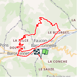

Lengte
24 km

Max. hoogte
1790 m

Positief hoogteverschil
780 m
Km-Effort
34 km

Min. hoogte
1133 m

Negatief hoogteverschil
781 m
Boucle
Ja
Datum van aanmaak :
2019-08-11 07:28:00.0
Laatste wijziging :
2019-08-11 09:25:51.356
1h57
Moeilijkheid : Zeer moeilijk

Gratisgps-wandelapplicatie
 SityTrail
IGN / Geografische instituten
SityTrail Plus
De wereld gaat voor u open
Over ons
Tocht Mountainbike van 24 km beschikbaar op Provence-Alpes-Côte d'Azur, Alpes-de-Haute-Provence, Enchastrayes. Deze tocht wordt voorgesteld door phil21.
Plaatsbepaling
Land:
France
Regio :
Provence-Alpes-Côte d'Azur
Departement/Provincie :
Alpes-de-Haute-Provence
Gemeente :
Enchastrayes
Locatie:
Unknown
Vertrek:(Dec)
Vertrek:(UTM)
314815 ; 4916934 (32T) N.
Opmerkingen