Tocht Mountainbike Villasavary - circuit VTT N°6 - Les Vallons de l Autan - Photo

circuit VTT N°6 - Les Vallons de l Autan

 leroj73
leroj73

Gebruiker

© OpenStreetMap contributors
Lengte
Lengte
59 km
Max. hoogte
Max. hoogte
400 m
Positief hoogteverschil
1339 m
Km-Effort
Km-Effort  
77 km
Min. hoogte
Min. hoogte
180 m
Negatief hoogteverschil
1338 m
Boucle
Boucle
Ja
Datum van aanmaak :
2019-08-13 16:14:01.362
Laatste wijziging :
2019-08-13 16:18:08.575

(0 Bericht)

Mountainbike
Mountainbike
5h00
Moeilijkheid : Zeer moeilijk

Scan deze QR-code om de tocht te openen in de SityTrail-applicatie

Gratisgps-wandelapplicatie

Logo SityTrail SityTrail

IGN / Geografische instituten

SityTrail uit de App Store downloaden SityTrail uit Google Play downloaden

Logo SityTrail SityTrail Plus

De wereld gaat voor u open

SityTrail uit de App Store downloaden SityTrail uit Google Play downloaden SityTrail op Huawei AppGallery downloaden

Over ons

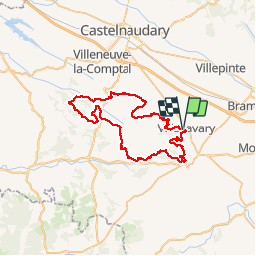
Tocht Mountainbike van 59 km beschikbaar op Occitanië, Aude, Villasavary. Deze tocht wordt voorgesteld door leroj73.

Beschrijving

tracé par lous pounpils, les vttistes de villasavary;
un super site d'accueil et un travail hors norme méritent que  l'on y mette les crampons du spad, exigeant mais le paysage est juste magnifique....

Hoogteprofiel

Plaatsbepaling

Land:
France
Regio :
Occitanië
Departement/Provincie :
Aude
Gemeente :
Villasavary
Locatie:
Unknown
Vertrek:(Dec)
Vertrek:(UTM)
421595 ; 4785524 (31T) N.


Sluiten
Mijn abonnementen