


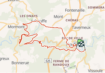
Houffalize - Achouffe

michelhardat
Gebruiker

Lengte
22 km

Max. hoogte
416 m

Positief hoogteverschil
627 m
Km-Effort
30 km

Min. hoogte
301 m

Negatief hoogteverschil
591 m
Boucle
Neen
Datum van aanmaak :
2014-12-10 00:00:00.0
Laatste wijziging :
2014-12-10 00:00:00.0
6h04
Moeilijkheid : Moeilijk

Gratisgps-wandelapplicatie
 SityTrail
IGN / Geografische instituten
SityTrail Plus
De wereld gaat voor u open
Over ons
Tocht Stappen van 22 km beschikbaar op Wallonië, Luxemburg, Houffalize. Deze tocht wordt voorgesteld door michelhardat.
Beschrijving
rando sur boucle vtt 6
Plaatsbepaling
Land:
Belgium
Regio :
Wallonië
Departement/Provincie :
Luxemburg
Gemeente :
Houffalize
Locatie:
Houffalize
Vertrek:(Dec)
Vertrek:(UTM)
699390 ; 5556729 (31U) N.
Opmerkingen