


raye sur authie

Martelpierre
Gebruiker

Lengte
12,6 km

Max. hoogte
97 m

Positief hoogteverschil
184 m
Km-Effort
15,1 km

Min. hoogte
14 m

Negatief hoogteverschil
179 m
Boucle
Ja
Datum van aanmaak :
2019-09-02 15:45:00.961
Laatste wijziging :
2019-09-02 17:22:11.594
1h08
Moeilijkheid : Heel gemakkelijk

Gratisgps-wandelapplicatie
 SityTrail
IGN / Geografische instituten
SityTrail Plus
De wereld gaat voor u open
Over ons
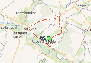
Tocht Wegfiets van 12,6 km beschikbaar op Hauts-de-France, Pas-de-Calais, Raye-sur-Authie. Deze tocht wordt voorgesteld door Martelpierre.
Beschrijving
par fond de val et le fedoye et deux incursion dans parties est goudronnées à partir du cimetière.
Plaatsbepaling
Land:
France
Regio :
Hauts-de-France
Departement/Provincie :
Pas-de-Calais
Gemeente :
Raye-sur-Authie
Locatie:
Unknown
Vertrek:(Dec)
Vertrek:(UTM)
425249 ; 5572008 (31U) N.
Opmerkingen