


Régordane 5 - Génolhac-Drulhes

nolsim
Gebruiker
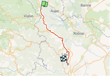

Lengte
32 km

Max. hoogte
563 m

Positief hoogteverschil
628 m
Km-Effort
41 km

Min. hoogte
234 m

Negatief hoogteverschil
888 m
Boucle
Neen
Datum van aanmaak :
2019-09-03 06:04:35.478
Laatste wijziging :
2019-09-03 15:07:14.668
9h01
Moeilijkheid : Moeilijk

Gratisgps-wandelapplicatie
 SityTrail
IGN / Geografische instituten
SityTrail Plus
De wereld gaat voor u open
Over ons
Tocht Stappen van 32 km beschikbaar op Occitanië, Gard, Génolhac. Deze tocht wordt voorgesteld door nolsim.
Beschrijving
Quelques beaux chemins mais beaucoup de goudron. Passage par les mines
Foto's


Plaatsbepaling
Land:
France
Regio :
Occitanië
Departement/Provincie :
Gard
Gemeente :
Génolhac
Locatie:
Unknown
Vertrek:(Dec)
Vertrek:(UTM)
575735 ; 4911189 (31T) N.
Opmerkingen