


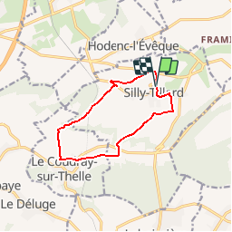
Silly tillard 10km

Djaie60
Gebruiker

Lengte
9,9 km

Max. hoogte
228 m

Positief hoogteverschil
167 m
Km-Effort
12,1 km

Min. hoogte
97 m

Negatief hoogteverschil
164 m
Boucle
Ja
Datum van aanmaak :
2019-09-09 14:06:56.0
Laatste wijziging :
2019-09-26 09:05:18.318
--
Moeilijkheid : Heel gemakkelijk

Gratisgps-wandelapplicatie
 SityTrail
IGN / Geografische instituten
SityTrail Plus
De wereld gaat voor u open
Over ons
Tocht Te voet van 9,9 km beschikbaar op Hauts-de-France, Oise, Silly-Tillard. Deze tocht wordt voorgesteld door Djaie60.
Plaatsbepaling
Land:
France
Regio :
Hauts-de-France
Departement/Provincie :
Oise
Gemeente :
Silly-Tillard
Locatie:
Unknown
Vertrek:(Dec)
Vertrek:(UTM)
438798 ; 5464083 (31U) N.
Opmerkingen