


Paiolive 28 août 2019

elorthiois
Gebruiker

Lengte
5,5 km

Max. hoogte
251 m

Positief hoogteverschil
101 m
Km-Effort
6,9 km

Min. hoogte
182 m

Negatief hoogteverschil
104 m
Boucle
Ja
Datum van aanmaak :
2019-08-28 06:15:55.827
Laatste wijziging :
2019-09-10 08:22:45.59
3h23
Moeilijkheid : Gemakkelijk

Gratisgps-wandelapplicatie
 SityTrail
IGN / Geografische instituten
SityTrail Plus
De wereld gaat voor u open
Over ons
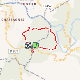
Tocht Stappen van 5,5 km beschikbaar op Auvergne-Rhône-Alpes, Ardèche, Les Vans. Deze tocht wordt voorgesteld door elorthiois.
Plaatsbepaling
Land:
France
Regio :
Auvergne-Rhône-Alpes
Departement/Provincie :
Ardèche
Gemeente :
Les Vans
Locatie:
Chassagnes
Vertrek:(Dec)
Vertrek:(UTM)
593812 ; 4916382 (31T) N.
Opmerkingen