


CLECYU-19 16:39:48

UDGI54
Gebruiker

Lengte
11,6 km

Max. hoogte
248 m

Positief hoogteverschil
425 m
Km-Effort
17,2 km

Min. hoogte
32 m

Negatief hoogteverschil
425 m
Boucle
Ja
Datum van aanmaak :
2019-09-13 10:10:34.521
Laatste wijziging :
2019-09-13 10:11:55.784
3h35
Moeilijkheid : Moeilijk

Gratisgps-wandelapplicatie
 SityTrail
IGN / Geografische instituten
SityTrail Plus
De wereld gaat voor u open
Over ons
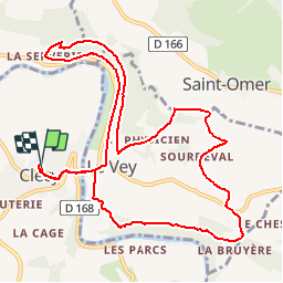
Tocht Stappen van 11,6 km beschikbaar op Normandië, Calvados, Clécy. Deze tocht wordt voorgesteld door UDGI54.
Plaatsbepaling
Land:
France
Regio :
Normandië
Departement/Provincie :
Calvados
Gemeente :
Clécy
Locatie:
Unknown
Vertrek:(Dec)
Vertrek:(UTM)
684472 ; 5421309 (30U) N.
Opmerkingen