


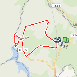
V2019 1.10 Tintry randonnée douce

clabidault
Gebruiker

Lengte
8 km

Max. hoogte
472 m

Positief hoogteverschil
117 m
Km-Effort
9,5 km

Min. hoogte
395 m

Negatief hoogteverschil
118 m
Boucle
Ja
Datum van aanmaak :
2019-09-18 06:53:04.203
Laatste wijziging :
2019-10-02 19:05:51.153
--
Moeilijkheid : Heel gemakkelijk

Gratisgps-wandelapplicatie
 SityTrail
IGN / Geografische instituten
SityTrail Plus
De wereld gaat voor u open
Over ons
Tocht Te voet van 8 km beschikbaar op Bourgondië-Franche-Comté, Saône-et-Loire, Tintry. Deze tocht wordt voorgesteld door clabidault.
Beschrijving
24 Participants parcours modifié en raison de la pluie
Plaatsbepaling
Land:
France
Regio :
Bourgondië-Franche-Comté
Departement/Provincie :
Saône-et-Loire
Gemeente :
Tintry
Locatie:
Unknown
Vertrek:(Dec)
Vertrek:(UTM)
613768 ; 5198479 (31T) N.
Opmerkingen