


autour de caban

Coryphene
Gebruiker
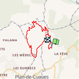

Lengte
15,7 km

Max. hoogte
468 m

Positief hoogteverschil
450 m
Km-Effort
22 km

Min. hoogte
192 m

Negatief hoogteverschil
441 m
Boucle
Ja
Datum van aanmaak :
2019-10-10 07:44:19.509
Laatste wijziging :
2019-10-10 14:15:34.544
6h28
Moeilijkheid : Medium

Gratisgps-wandelapplicatie
 SityTrail
IGN / Geografische instituten
SityTrail Plus
De wereld gaat voor u open
Over ons
Tocht Stappen van 15,7 km beschikbaar op Provence-Alpes-Côte d'Azur, Bouches-du-Rhône, Allauch. Deze tocht wordt voorgesteld door Coryphene.
Plaatsbepaling
Land:
France
Regio :
Provence-Alpes-Côte d'Azur
Departement/Provincie :
Bouches-du-Rhône
Gemeente :
Allauch
Locatie:
Unknown
Vertrek:(Dec)
Vertrek:(UTM)
701246 ; 4804770 (31T) N.
Opmerkingen