


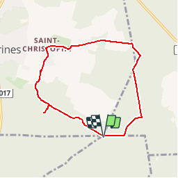
Le Chêne à l'Image _ 6,8 km

Pousscailleux
Gebruiker

Lengte
6,8 km

Max. hoogte
182 m

Positief hoogteverschil
115 m
Km-Effort
8,3 km

Min. hoogte
113 m

Negatief hoogteverschil
115 m
Boucle
Ja
Datum van aanmaak :
2014-12-10 00:00:00.0
Laatste wijziging :
2014-12-10 00:00:00.0
1h48
Moeilijkheid : Gemakkelijk

Gratisgps-wandelapplicatie
 SityTrail
IGN / Geografische instituten
SityTrail Plus
De wereld gaat voor u open
Over ons
Tocht Stappen van 6,8 km beschikbaar op Hauts-de-France, Oise, Chamant. Deze tocht wordt voorgesteld door Pousscailleux.
Beschrijving
Départ du parking du Poteau des Blancs Sablons.
Le Chêne à l'Image est un arbre vénéré sur lequel, en haut du tronc, a été installée une reproduction de la Vierge Marie.


Plaatsbepaling
Land:
France
Regio :
Hauts-de-France
Departement/Provincie :
Oise
Gemeente :
Chamant
Locatie:
Unknown
Vertrek:(Dec)
Vertrek:(UTM)
471773 ; 5454834 (31U) N.
Opmerkingen