


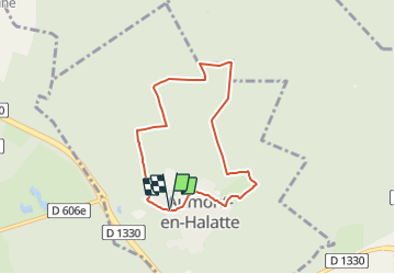
Le mont Alta _ 6,1 km

Pousscailleux
Gebruiker

Lengte
6,1 km

Max. hoogte
152 m

Positief hoogteverschil
95 m
Km-Effort
7,4 km

Min. hoogte
89 m

Negatief hoogteverschil
97 m
Boucle
Ja
Datum van aanmaak :
2014-12-10 00:00:00.0
Laatste wijziging :
2014-12-10 00:00:00.0
1h37
Moeilijkheid : Gemakkelijk

Gratisgps-wandelapplicatie
 SityTrail
IGN / Geografische instituten
SityTrail Plus
De wereld gaat voor u open
Over ons
Tocht Stappen van 6,1 km beschikbaar op Hauts-de-France, Oise, Aumont-en-Halatte. Deze tocht wordt voorgesteld door Pousscailleux.
Beschrijving
Départ du parking près de l'église.


Plaatsbepaling
Land:
France
Regio :
Hauts-de-France
Departement/Provincie :
Oise
Gemeente :
Aumont-en-Halatte
Locatie:
Unknown
Vertrek:(Dec)
Vertrek:(UTM)
467197 ; 5453072 (31U) N.
Opmerkingen