


10 è etapes ConquesLlivinhac le haut

RoMo
Gebruiker
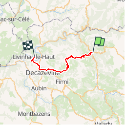

Lengte
25 km

Max. hoogte
581 m

Positief hoogteverschil
920 m
Km-Effort
37 km

Min. hoogte
177 m

Negatief hoogteverschil
979 m
Boucle
Neen
Datum van aanmaak :
2019-10-21 09:04:45.047
Laatste wijziging :
2019-10-21 09:06:51.805
--
Moeilijkheid : Moeilijk

Gratisgps-wandelapplicatie
 SityTrail
IGN / Geografische instituten
SityTrail Plus
De wereld gaat voor u open
Over ons
Tocht Te voet van 25 km beschikbaar op Occitanië, Aveyron, Conques-en-Rouergue. Deze tocht wordt voorgesteld door RoMo.
Plaatsbepaling
Land:
France
Regio :
Occitanië
Departement/Provincie :
Aveyron
Gemeente :
Conques-en-Rouergue
Locatie:
Unknown
Vertrek:(Dec)
Vertrek:(UTM)
452099 ; 4938562 (31T) N.
Opmerkingen