


Lèsves

PhilippeetEvelyne
Gebruiker
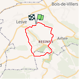

Lengte
9 km

Max. hoogte
262 m

Positief hoogteverschil
159 m
Km-Effort
11,1 km

Min. hoogte
156 m

Negatief hoogteverschil
161 m
Boucle
Ja
Datum van aanmaak :
2019-10-22 12:04:08.154
Laatste wijziging :
2019-11-05 06:37:29.546
--
Moeilijkheid : Gemakkelijk

Gratisgps-wandelapplicatie
 SityTrail
IGN / Geografische instituten
SityTrail Plus
De wereld gaat voor u open
Over ons
Tocht Te voet van 9 km beschikbaar op Wallonië, Namen, Profondeville. Deze tocht wordt voorgesteld door PhilippeetEvelyne.
Plaatsbepaling
Land:
Belgium
Regio :
Wallonië
Departement/Provincie :
Namen
Gemeente :
Profondeville
Locatie:
Lesve
Vertrek:(Dec)
Vertrek:(UTM)
627379 ; 5581903 (31U) N.
Opmerkingen