


Vesqueville

pierlan
Gebruiker
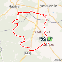

Lengte
16,2 km

Max. hoogte
551 m

Positief hoogteverschil
263 m
Km-Effort
19,7 km

Min. hoogte
427 m

Negatief hoogteverschil
265 m
Boucle
Ja
Datum van aanmaak :
2019-10-23 13:36:43.536
Laatste wijziging :
2019-10-23 14:10:47.141
--
Moeilijkheid : Heel gemakkelijk

Gratisgps-wandelapplicatie
 SityTrail
IGN / Geografische instituten
SityTrail Plus
De wereld gaat voor u open
Over ons
Tocht Trail van 16,2 km beschikbaar op Wallonië, Luxemburg, Libramont-Chevigny. Deze tocht wordt voorgesteld door pierlan.
Plaatsbepaling
Land:
Belgium
Regio :
Wallonië
Departement/Provincie :
Luxemburg
Gemeente :
Libramont-Chevigny
Locatie:
Bras
Vertrek:(Dec)
Vertrek:(UTM)
671643 ; 5538099 (31U) N.
Opmerkingen