


Rogeville

PhilippeC54
Gebruiker
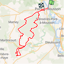

Lengte
37 km

Max. hoogte
347 m

Positief hoogteverschil
669 m
Km-Effort
46 km

Min. hoogte
178 m

Negatief hoogteverschil
671 m
Boucle
Neen
Datum van aanmaak :
2019-11-01 07:26:52.851
Laatste wijziging :
2019-11-27 07:44:28.642
3h21
Moeilijkheid : Heel gemakkelijk

Gratisgps-wandelapplicatie
 SityTrail
IGN / Geografische instituten
SityTrail Plus
De wereld gaat voor u open
Over ons
Tocht Mountainbike van 37 km beschikbaar op Grand Est, Meurthe-et-Moselle, Pont-à-Mousson. Deze tocht wordt voorgesteld door PhilippeC54.
Beschrijving
monotraces Rogeville & Puvenelle
Plaatsbepaling
Land:
France
Regio :
Grand Est
Departement/Provincie :
Meurthe-et-Moselle
Gemeente :
Pont-à-Mousson
Locatie:
Unknown
Vertrek:(Dec)
Vertrek:(UTM)
284267 ; 5420957 (32U) N.
Opmerkingen