


Bois de cuite

PhilippeC54
Gebruiker

Lengte
26 km

Max. hoogte
347 m

Positief hoogteverschil
539 m
Km-Effort
33 km

Min. hoogte
176 m

Negatief hoogteverschil
537 m
Boucle
Neen
Datum van aanmaak :
2019-11-11 07:32:23.164
Laatste wijziging :
2019-11-11 10:42:05.067
3h08
Moeilijkheid : Heel gemakkelijk

Gratisgps-wandelapplicatie
 SityTrail
IGN / Geografische instituten
SityTrail Plus
De wereld gaat voor u open
Over ons
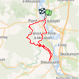
Tocht Mountainbike van 26 km beschikbaar op Grand Est, Meurthe-et-Moselle, Pont-à-Mousson. Deze tocht wordt voorgesteld door PhilippeC54.
Beschrijving
monotraces Bois de Cuite, Jezain, Puvenelle
Plaatsbepaling
Land:
France
Regio :
Grand Est
Departement/Provincie :
Meurthe-et-Moselle
Gemeente :
Pont-à-Mousson
Locatie:
Unknown
Vertrek:(Dec)
Vertrek:(UTM)
284243 ; 5420953 (32U) N.
Opmerkingen