


ec

PhilippeC54
Gebruiker
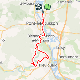

Lengte
27 km

Max. hoogte
324 m

Positief hoogteverschil
286 m
Km-Effort
31 km

Min. hoogte
176 m

Negatief hoogteverschil
286 m
Boucle
Ja
Datum van aanmaak :
2019-11-20 13:06:40.224
Laatste wijziging :
2019-11-20 17:01:48.085
2h47
Moeilijkheid : Heel gemakkelijk

Gratisgps-wandelapplicatie
 SityTrail
IGN / Geografische instituten
SityTrail Plus
De wereld gaat voor u open
Over ons
Tocht Mountainbike van 27 km beschikbaar op Grand Est, Meurthe-et-Moselle, Pont-à-Mousson. Deze tocht wordt voorgesteld door PhilippeC54.
Plaatsbepaling
Land:
France
Regio :
Grand Est
Departement/Provincie :
Meurthe-et-Moselle
Gemeente :
Pont-à-Mousson
Locatie:
Unknown
Vertrek:(Dec)
Vertrek:(UTM)
284424 ; 5422308 (32U) N.
Opmerkingen